Ignoramus Immigrant MP Doesn’t Know the Geography of Canada
Ignoramus Immigrant MP Doesn’t Know the Geography of Canada
[Yasir Naqvi is a Pakistani import. Born in Karachi, he came to Canada at age 15. He certainly did not learn much about Canadian geography. His ignorance and his colour were no impediments for rapid advancement in Liberal electoral politics. He was elected MPP for Ottawa Centre. He quickly rose within the ranks of the radical lesbian premier Kathleen Wynn’s government. He became Attorney General. One of his last acts before the 2018 debacle which pulverized the Wynne regime and cost him his seat, was to authorize Sec. 318 or “hate law” charges against Dr. James Sears, editor, and LeRoy St. Germaine, publisher of the satirical YOUR WARD NEWS. Apparently, Naqvi’s father had been jailed in Pakistan for being a proponent of democracy. Clearly, the son had learned little about such democratic principles as freedom of speech and a free press. By 2021, Naqvi was back in politics now as a federal Liberal MP. For Canada (Dominion) Day Naqvi put out a postcard. It features a map of Canada that looks as if it was drawn by a child. It is filled with egregious errors. Of course, the elite’s narrative is that Canada is systemically racist. Interestingly, that hasn’t stopped this ignorant foreigner from climbing the ladder of politics. — Paul Fromm]
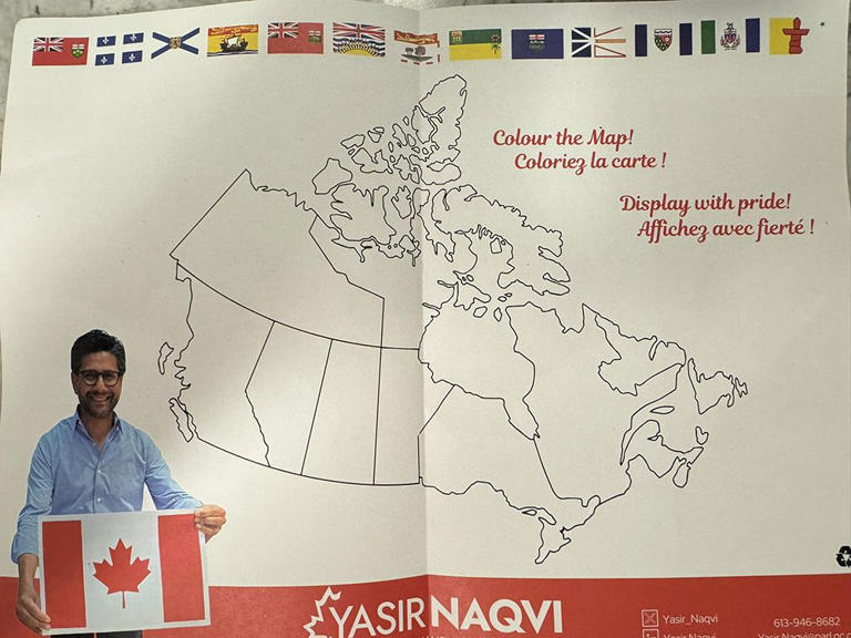
A Liberal MP’s map of Canada has drawn attention for omitting provinces and territories and blurring some key borders.
In a pre-Canada Day effort at outreach, MP Yasir Naqvi sent his constituents in Ottawa Central a flyer with Naqvi’s contact information — and a poorly rendered map to “Display with pride!”
The blank colouring map is missing Prince Edward Island, the maritime province nestled above New Brunswick and Nova Scotia. (In fact, our smallest province has a long history of being forgotten, including in a book of Champlain’s voyages dating back to 1613, as one historian found out).
On the other side of the map, the Northwest Territories and the Yukon are also given short shrift, represented as a single landmass with no dividing border.
Tory MP Michelle Rempel Garner shared a image of the flyer in a post on X pointing out these and other cartographic oversights.
“Pre Canada Day fun time,” the post begins. “Can you spot the error that whoever was supposed to proof this mailer didn’t catch?”
Rempel Garner notes another “fairly significant” oversight: the provinces of Quebec, New Brunswick and Nova Scotia are lumped together as one. (National Post, June 25, 2024)